Why can't I see my graphics and labels while I'm editing?
The selected line/node marker drawing environment of the extension erases all graphics (as well as the little black squares ArcView draws around selected features in the editable theme) when it draws the nodes and selected lines. You may see your graphics and labels draw but be instantly erased; they are still there, they just aren't visible. If you want to see them while you are editing a line shapefile, you have to use Vertex Edit mode. If you use the Mark Intersections button, the same will be true of the intersection markers (which are actually graphic points). The fundemental difference between graphics (shapes, labels) on the View and shapes such as the node markers and selection-color lines is that the former are stored with the View until you specifically delete them while the latter are just drawn on top of the View and disappear as soon as the View redraws.
I built my line shapefile into polygons with no error messages but some of the polygons didn't get built at all, or some polygons seem to have been combined into one.
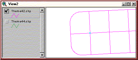
One way this can happen is if you have four (or more) lines that appear to meet at a corner but they don't actually meet at a common node. Sometimes two lines cross without meeting (the Builder program doesn't check for this) and sometimes two pairs of lines each meet at a pseudonode but all four don't meet at the same point:
Try editing the line shapefile using the Parcel Editor and zoom in to the area near the polygon that didn't build properly. If there is a blue pseudonode marker at a point that looks like it should be a 4-or-more line intersection, you need to zoom way, way in and snap all the lines' endpoints together. If the problem is lines that cross each other, you can find them by using the Mark Intersections button before building.
When trying to build, I got an error message that said '!!2 identical angles--overlapping lines!!!' and a bunch of numbers.
This means there are two lines that end at the same node that leave the node at the same angle (usually the next vertex of both lines is the same). This usually happens for two reasons: either you have two lines that lie directly on top of one another (the two lines are identical), or you have two lines that share an endpoint and the vertex after the endpoint of one of the lines mistakenly snapped to the second vertex of the other line (i.e. the two lines share a segment). To help you fix the problem, Builder will select the problematic lines and zoom to them if it gives you this error message; also, the numbers in the error message are the record numbers of the offending lines in the table (the record number is usually the sequential row number in the table, minus one), plus the problematic angle measurements, which are equal or 180 degrees apart. If the two lines are identical, you need to delete one of them using the Select Previous/Next Feature buttons. If the two lines merely share a segment, you need to pull one of the lines' vertex away from the other's vertex with the snapping set to off.
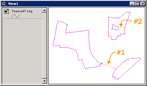
While building, I got an error message that said 'The following lines have rpoly = lpoly:' followed by some numbers.
Sometimes this error message is o.k., specifically when you have a line that isn't meant to be a polyon boundary, i.e. a survey connector line that joins two parcels (#1 in image), or if the line cuts through a single polygon and thus the line has the same polygon on both sides (#2 in image):
This line will just be ignored and the other parcels should build properly. Usually, however, this error will result in an improper build because your lines are not topologically correct. This often occurs when you have an intersection like this one:
where there should be a four-way intersection but instead there are two two-way intersections (you can tell something is wrong because there appears to be pseudonode markers at an intersection where there should be none), or when you have two lines that cross each other with no 'nodes' at all. Both of these problems can be avoided by using the Mark Intersections button before trying to build.
I'm editing a line shapefile (NOT using the parcel editor dialog) but the lines are still drawing yellow and the nodes are being drawn.
As long as the extension is loaded, the edit environment for line shapefile editing will be applied. To stop this, unload the extension by going to File--> Extensions and uncheck the box next to the Data Editor extension.