This button (which changes its label from 'Edit Survey' to 'Edit Comments' depending on which page you are on) lets you switch between the two pages of the Survey Entry dialog.
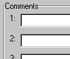
Comments fields
It is important to enter clear and concise comments into the four lines provided. They will help you remember what part of what survey is in the file when it comes time to draw the file to an edit session. They will also remind you of any irregularities in the survey (for instance tie courses or courses that connect to a landmark but are not part of the parcel boundary. Suggested comments you could enter:
Line 1:
Could include the current owner and the town where the parcel is located.
Line 2:
Could include the grantor or former owner's name, the parcel number, and the acreage.
Line 3:
Could include a description of where the survey starts and ends, what part of the survey is in this file (if the survey is broken up into several files), and any important reminders about unusual features of the survey.
Line 4:
This could contain the name of the surveyor, the date the property was surveyed, and any other information that could help identify the sheet or deed the survey was taken from.
You will find these comments very helpful if you need to come back to the file later. As a reminder, the 'Draw Survey' tool on the Parcel Editor will show you the comments before it draws a survey file to the display.
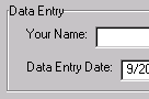
Name and Date fields
Enter your name and today's date in the fields provided (the date will already be entered for you). This will help you keep track of who entered a survey text file and when.
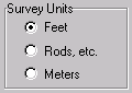
Choosing Units
Each survey file must use the same units throughout. When you save the file it saves whatever units you specified the survey is in, and the distance portion of each course is assumed to be in those units. Usually the paper survey or deed will indicate clearly what units it is in (remember, the
symbol ' indicates feet, i.e. 406.25' ). If it is not indicated, assume that it is in feet if the property surveyed is within the United States. Often older surveys are in rods. If your survey contains mention of Chains, Rods or Links, perhaps in combination with Feet, choose Rods as your units; you will be able to enter a combination of all these units.